Weser Cycle Route, 8th stage: From Nordenham/Bremerhaven to Cuxhaven
Nordenham/Bremerhaven → Cuxhaven
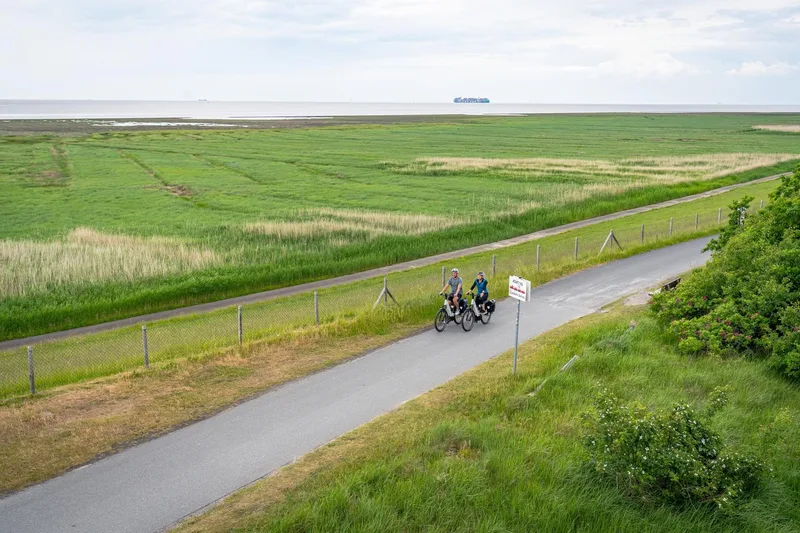
The final stage of the Weser Cycle Route leads you along the North German dike landscapes and always parallel to the Weser River.
From Wremen onwards begins the official estuary area of the Weser into the North Sea.
Along the route are the idyllic cutter harbors of the Wurster North Sea Coast, the Wernerwald nature reserve, and finally the North Sea spa town of Cuxhaven.
The official end of the route is reached at the northernmost point of Lower Saxony, at the height of the Kugelbake in Cuxhaven.
From the dike, you can let your gaze wander over the UNESCO World Natural Heritage Wadden Sea and the world shipping route Elbe.
Length
56.2 km
Walking time
approx. 14:15 h
Ascent
35 m
Descent
41 m
Walking time without breaks, calculated from length and elevation using the hiking standard DIN 33466 (per hour: 4 km, 300 m uphill, 500 m downhill).
Elevation profile
0 m10 m20 m
14 km26 km44 km0 km56 km
Elevation profile calculated by Fairvisit from satellite elevation data. Ascent and descent usually differ by up to about 10 %, more on steep terrain.
Start
Coordinates53.51901, 8.53466
Nordenham/Bremerhaven
Along the way
Finish
Coordinates53.89175, 8.68176
Cuxhaven
Nearby
Image rights: Weser-Radweg Infozentrale, Weserbergland Tourismus e.V. · CC BY-SA 4.0
Image rights: Weser-Radweg Infozentrale, Maximilian Semsch · CC BY-SA 4.0
Image rights: Weser-Radweg Infozentrale, Maximilian Semsch · CC BY-SA 4.0
Image rights: Weser-Radweg Infozentrale, Maximilian Semsch · CC BY-SA 4.0
Image rights: Weser-Radweg Infozentrale, Maximilian Semsch · CC BY-SA 4.0
Image rights: Weser-Radweg Infozentrale, Maximilian Semsch · CC BY-SA 4.0
Image rights: Weser-Radweg Infozentrale, Maximilian Semsch · CC BY-SA 4.0
Image rights: Weser-Radweg Infozentrale, Maximilian Semsch · CC BY-SA 4.0
Image rights: Weser-Radweg Infozentrale, Maximilian Semsch · CC BY-SA 4.0
Image rights: Weser-Radweg Infozentrale, Maximilian Semsch · CC BY-SA 4.0
Image rights: Weser-Radweg Infozentrale, Maximilian Semsch · CC BY-SA 4.0
Image rights: Weser-Radweg Infozentrale, Maximilian Semsch · CC BY-SA 4.0
Saved
Fairvisit teamOffline
Hi there!
A question or some feedback? Drop us a line – we'd love to hear from you.
We're offline right now.
Leave us a message and we'll get back to you by email:
Thanks! We've got your message and will reply by email.